Indian River Systems
Classification Based on Geological Evolution
- Antecedent Rivers: Rivers that existed before the upliftment of the Himalayas and cut deep gorges through the mountains to maintain their original courses.
Examples: Indus, Sutlej, Brahmaputra.
- Subsequent Rivers: Rivers that formed after the primary regional relief and landscape were established.
Examples: Chambal, Betwa, Ken, Son.
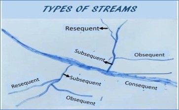
- Superimposed Rivers: Rivers that established its course on a younger overlying rock layer and kept that path as it eroded down into a completely different, older rock structure beneath.
Examples: Damodar, Subarnarekha, Chambal.
Drainage Patterns of India
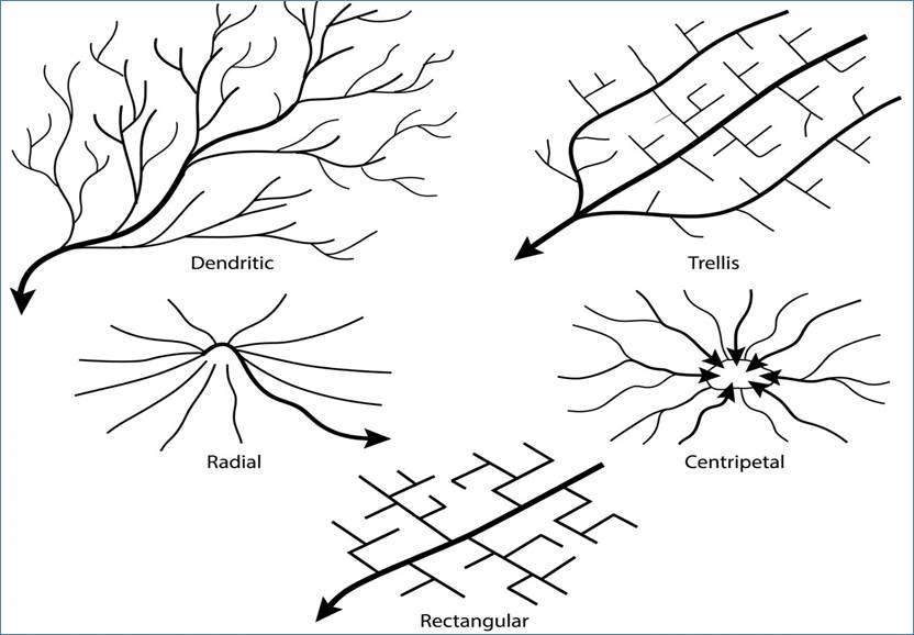
| Drainage Pattern | Description | Example |
| Dendritic | Tree-branch-like pattern where tributaries join the main river at acute angles (< 90°). | Indus, Ganga, Mahanadi. |
| Trellis | Rectangular pattern where primary tributaries run parallel and smaller ones join at right angles ( 90°). | Alaknanda. |
| Radial | Streams flow outward in all directions from a central high point. | Narmada, Son. |
| Centripetal | Streams converge from surrounding high areas toward a central low point. | Rivers drain into Lake Sambhar (Rajasthan), Dead Sea basin. |
Classification:
Indian rivers are classified into –
1. Himalayan Rivers (perennial, snow-fed, antecedent).
2. Peninsular Rivers (seasonal, rain-fed, subsequent).
1. Himalayan River Systems
A. Indus River System:
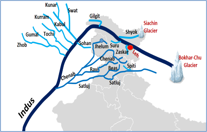
- Origin: Mansarovar Lake region (Bokhar Chu Glacier, Tibet).
- Course: Flows through Ladakh, Pakistan, and drains into the Arabian sea.
- Length: 3180 km. (709 km in India)
- Right-Bank Tributaries: Shyok, Gilgit, Hunza, Swat, Kabul.
- Left-Bank Tributaries (Panjnad): Jhelum, Chenab, Ravi, Beas, Sutlej.
| River | Source | Project / Key Fact |
| Jhelum | Verinag Spring (J&K) | Flows through Wular Lake,Uri & Kishanganga Projects. |
| Chenab | Bara Lacha La Pass (HP) | Formed by Chandra and Bhaga, Baglihar & Salal Dams. |
| Ravi | Rohtang Pass (HP) | Flows between Pir Panjal and Dhauladhar,Ranjit Sagar Dam. |
| Beas | Beas Kund (HP),near Rohtang Pass | Lies entirely inside India, meets Sutlej at Harike Wetland. |
| Sutlej | Rakshas Tal (Tibet) | passes Shipki La, Bhakra Nangal Dam. |
B. The Ganga River System:
- Origin: Gomukh ice cave of Gangotri Glacier, Uttarakhand.
- Course: Passes Uttarakhand,UP,Bihar,West Bengal & Bangladesh into the Bay of Bengal.
- Length: 2525 km
- Panch Prayag:
1) Vishnuprayag = Dhauliganga + Alaknanda.
2) Nandaprayag = Nandakini + Alaknanda.
3) Karnaprayag = Pindar + Alaknanda.
4) Rudraprayag = Mandakini + Alaknanda.
5) Devprayag = Bhagirathi + Alaknanda.
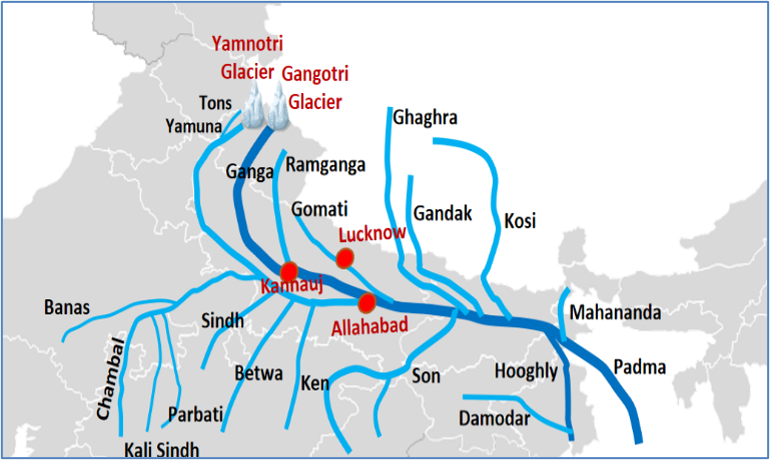
Right-Bank Tributaries:
| River | Origin | Key Features |
| Yamuna | Yamunotri Glacier (Uttarakhand) | 1. Largest & longest right-bank tributary of the Ganga. 2. Joins Ganga at Prayagraj (Allahabad) 3. Major tributaries: Chambal, Betwa, Ken, and Tons. |
| Son | Amarkantak Plateau | Major tributaries: Rihand and Koel. |
| Damodar | Khamarpat hill, Chota Nagpur Plateau (Jharkhand) | 1. Known as the “Sorrow of Bengal”. 2. Regulated by the Damodar Valley Corporation (DVC). |
Left-Bank Tributaries:
| River | Origin | Key features |
| Ramganga | Dudhatoli Hill Range | Flows through the Jim Corbett National Park. |
| Gomti | Gumat Taal(U.P) | purely plain-fed groundwater river. |
| Ghaghara | near Mansarovar Lake | 1. Trans-boundary river. 2. Known as Karnali in Nepal and Sarayu near Ayodhya. |
| Kosi | Tibet/Nepal border | 1. Known as the “Sorrow of Bihar”. 2. Highly dynamic river that shifts its course laterally over decades |
| Mahananda | Paglajhora Falls (W.B) | 1. Easternmost left-bank tributary of the Ganga in India. 2. Trans-boundary river. |
C. The Brahmaputra River System
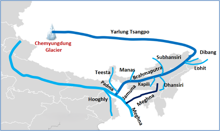
- Origin: Chemayungdung Glacier (Tibet) as Yarlung Tsangpo.
- Course: Flows east parallel to the Himalayas,enters Arunachal Pradesh at
- Namcha Barwa (called Siang / Dihang).
- Length: 2900 km (920 km in India)
- Right Bank Tributaries: Subansiri (antecedent), Kameng, Manas, Teesta, Sankosh.
- Left Bank Tributaries: Dibang, Lohit, Dhansiri, Burhi Dihing
- Forms Majuli Island (world’s largest river island) in Assam.
2.Peninsular River Systems
A. East-Flowing Peninsular Rivers (Bay of Bengal Drainage)
| River | Origin | Tributaries | Key features |
| Mahanadi (890 km) | Sihawa mountain (Chhattisgarh) | Seonath, Hasdeo, Mand, Ib, Ong, Tel. | Hirakud Dam |
| Godavari (1465 km) | Trimbakeshwar (Maharashtra) | Penganga, Indravati, Pranhita, Sabari, Manjira | 1. Known as Dakshin / Vriddha Ganga 2. Longest Peninsular river |
| Krishna (1400 km) | Mahabaleshwar (Maharashtra) | Tungabhadra, Bhima, Koyna, Ghataprabha, Malaprabha, Musi | Almatti, Srisailam, Nagarjuna Sagar Dam |
| Kaveri (800 km) | Brahmagiri Hills (Karnataka) | Hemavati, Shimsha, Arkavathi, Kabini, Amaravati | Krishna Raja Sagar, Mettur Dam |
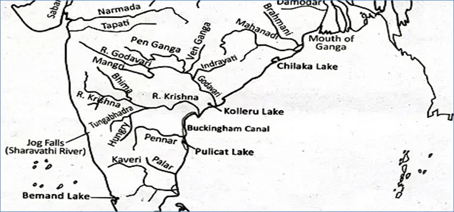
B. West-Flowing Peninsular Rivers (Arabian Sea Drainage)
| River | Origin | Key features |
| Narmada | Amarkantak Plateau (MP) | 1. It flows in a rift valley between Vindhya and Satpura ranges. 2. Dhuandhar Falls,Sardar Sarovar Dam, Indira Sagar Dam. |
| Tapti (Tapi) | Multai, Betul district (MP) | 1. It flows in a rift valley south of Satpura Range. 2. Ukai Dam, Kakrapar Dam |
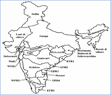
Important points:
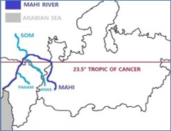
- Mahi river is the only river that crosses the Tropic of Cancer twice.
- Sharavati river forms Jog Falls (Karnataka).
- Periyar and Pemba river flows in Kerala.